Region:
Great SouthLength:
105 kmDuration:
1.25 hrsSubmitted By:
MC RiderSummary
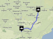
The road from Borden to Mt Barker travels 128 km through the spectacular Stirling Range National Park.
Ride Description
The town of Borden, named after Canada’s eighth Prime Minister, is located in the wheat belt of Western Australia. This route travels east to west through the Sterling Range National Park. The only tarred road in the area connects Albany to Gnowangerup. A short offshoot leads to a parking area on the side of Bluff Knoll, the highest piece of land in the Stirling Range, and the only place in Western Australia where snow is likely to fall. The other roads through the park are gravel but are generally in good shape.
The road that runs east to west from Chester Pass Rd. to the intersection at Mondurup Peak is particularly spectacular. There are several lookouts that offer beautiful panoramic views of the plains below along the route.
Directions
There are few roads in the Stirling Range National Park. A paved stretch runs between Albany and Gnowangerup. The rest of the roads are gravel. Take Chester Pass Rd. to the intersection at Mondurup Peak and turn south. Cross the Kalgan River and carry on to Mt. Barker.
View Motorbike Ride from Devonport to Hampshire in a larger map
Download GPX
Best Thing About This Ride
The scenery in the Stirling Range National Park is spectacular.
What Else To Look Out For
The Army sometimes conducts exercises in the range so watch out for military vehicles on the roads. The park abounds with beautiful wildflowers and Mt. Barker is in wine country.
No Responses to “Motorbike Ride from Borden to Mount Barker”