Region:
Hawke's BayLength:
316 kmDuration:
4 hrsSubmitted By:
MC RiderRide Summary
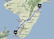
This is a long trail that links the main towns of Napier and Wellington, and takes in the lowest point of North Island.
Ride Description
This route begins comfortably with gentle sweeping curves and unremarkable undulations, but once you’ve got into it properly, and left the main routes behind, you’ll experience a long drive of sharp turns and unexpected corners as you wend your way southwards. You pass through plenty of small villages and with a relaxed, country feel, but also challenge your nerves on the high mountain pass of the Rimutakas.
Directions
Leave Napier on the SH50 or the SH2 and head towards Takapau where your only option is the SH2 southwards. When you reach the junction at Woodville, briefly jump on the SH3 before turning left onto the SH57 and heading south once more. At Ohau, you’ll turn left onto the SH1 and follow it all the way into Wellington.
View Motorbike Ride from Napier to Wellington in a larger map
Best Thing About This Ride
You can make this route as hard or as easy as you like, but whichever route you decide, there will still be challenges to enjoy and views to admire along the way.
What Else To Look Out For
Don’t get your speed up as you get into the tricky sections, because some of these corners are unexpectedly tight. Fuel up before leaving Napier and take every opportunity you can after that, because some sections are noticeably barren when it comes to fuelling stations.
No Responses to “Motorbike Ride from Napier to Wellington”