Region:
EastlandsLength:
215 kmDuration:
2.5 hrsSubmitted By:
MC RiderRide Summary
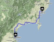
This winding route travels south along the SH2 on a 223km ride through the lowlands and coastlands of the eastern edge of the North Island.
Ride Description
The route is an often twisty road that passes along the edges of the Te Urewera and Whirinaki National Parks. There is a choice for the rider just minutes outside Gisborne, with the option to travel the inland route or the coastal route until both roads rejoin at Wairoa. The rest of the ride moves inland and passes the picturesque Lake Tutira and the Tangoio Falls before heading back towards the sea and into the town of Napier.
Directions
Heading south from Gisborne, the split occurs just minutes outside the main built up area, with the SH2 route following the coast to the south, and the Tiniroto Road continuing to the west. Both these routes are roughly the same distance (around the 100km mark) and arrive a Wairoa where they merge and continue south on the SH2 into Napier.
View Motorbike Ride from Gisborne to Napier in a larger map
Download GPX
Best Thing About This Ride
The town of Wairoa acts as a great stopping place and watering hole for the weary traveller. Riders taking the inland Tiniroto Road will find it easier to make a detour into the Lake Waikaremoana area just inside the Te Urewera National Park, which is perfect for lengthening the trip.
What Else to Look Out For
The inland route is less popular with law enforcement, which makes it popular with bikers. It is also a more challenging route, with tight corners that need care.
No Responses to “Motorbike Ride from Gisborne to Napier”