Region:
Alpine RegionLength:
30 kmDuration:
30 minsSubmitted By:
MSBRRide Summary
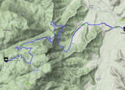
This 27-kilometre ride features a corner ratio of 85% and a mix of slow, medium, and fast corner speeds. The bitumen is grippy, but there are occasional bumps. You are likely to meet a car every 5 minutes in the summer.
Ride Description
A flowing, corner-rich uphill ride ascending to the apex of Mount Buffalo at its end, this road begins in Porepunkah, and is an enjoyable route for riding. The road surface has excellent grip despite a few bumps, and you can enjoy the bequritul views as you climb the flanks of the mountain. Beginning at Porepunkah, the roadway is wide and smooth for the first 3 kilometres, allowing for decent corner speeds.
After 3 kilometres, you will arrive at a National Parks toll booth, which charges a rather expnsive fee for entry, but which only collects tolls until 4:30 PM. Thereafter, entrance is free by default, and since the sun does not set for another 4 ½ hours in summertime, evening visits to avoid the toll are possible. The road surface temperature and visibility are excellent almost until nightfall.
After the toll booth, the road and corners are more in the “medium-speed” category, with two 25 kilometre per hour hairpin bends at the middle point of the road. More sharp bends, which have a slow corner speed, are found as you approach the summit of the mountain. All of the road is well signposted and kept in good condition thanks to being a National Parks road, and you may also enjoy roll rides downslope on your return, with your engine off and allowing gravity to do its work.
When you are 25 kilometres from Porepunkah and up on the side of the mountain, you will have a T-junction choice between turning left to the Mount Buffalo Chalet and right to the Horn. Mt. Buffalo is named for its shape, which resembles that of a buffalo from certain directions, and is used for cross-country skiing in the winter and hang-gliding in the summer, with enthusiasts using a 500-meter or more sheer cliff face as their launching point. As you might guess from this, the Horn is the high point of the plateau.
If you turn left to the Mt. Buffalo Chalet, you will find it after only 2 kilometres – a place where you can drink Devonshire tea to the accompaniment of summer-only ragtime music provided by a jazz quartet. Turning right to the Horn will place you on an 8-kilometre stretch of road, of which the first 6 kilometres are paved. This road is tight and not particularly free-flowing, but gives good views of nearby mountains and the lake, which looks pleasant but is too frigid to swim in, summer or winter. This area is favored by bush walkers. The Horn, a tall outcropping of rocks, is reached by a twenty minute climb, but offers magnificent vistas and amply repays a visit.
Arguably the best mountain-pass areas in the region for camping, exceeding Falls Creek, Mt. Buller, and Mt. Hotham.
Directions
Porepunkah is reached by taking the King Valley Highway and the Oxley Highway.
Best Thing About This Ride
The ride itself, with its many enjoyable corners and the good road surface throughout most of its length, is the best part of this road.
What Else To Look Out For
The worst hazards encountered on this road are the steep entry fee at the National Parks gate, and the hairpin turns at the midpoint and at several places on the mountainside.
No Responses to “Motorbike Ride from Porepunkah to Mt Buffalo”