Region:
Alpine RegionLength:
50 kmDuration:
1 hrSubmitted By:
MC RiderRide Summary
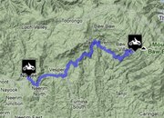
This ride is 50 kilometres long from Noojee to the summit of Mt. Baw Baw. The surface is both bump-free and grippy.
Ride Description
The road up Mt. Baw Baw – a center for cross-country skiing in winter – is an extremely difficult, technical road that is suitable for advanced riders who are looking for a real challenge. Most of the ride’s length consists of very sharp, twisting, unrelenting corners that give you no respite and are not forgiving of errors or inattention. The only exception to this is the first 10 kilometres, where the corners allow medium to fast speeds and there are a few short straightaways.
The road’s main portion is very narrow and has no runoff, part of the reason why you cannot allow yourself the luxury of getting distracted while negotiating it. High winds occasionally cover the surface in fallen leaves as well. Novices should not ride on this route, though the experienced may enjoy it. You should also note that there is nowhere to get fuel on this ride once you have left Noojee.
Directions
Lying 100 kilometres straight east from Melbourne, Noojee can be reached from the east by driving through Lilydale to Yarra Junction and Powelltown. The southern approach is via the Princes Highway, through Longwarry North, Labertouche, Jindivick, Neerim South, Neerim East, and Neerim Junction. A slightly inferior southern route goes through Drouin and Neerim South.
Best Thing About This Ride
The implacable series of very tight, technical corners and the challenge they offer is the main attraction of this motorcycle route.
What Else To Look Out For
The main danger on the Noojee to Mt. Baw Baw road is from rare oncoming 4WDs, other than the technical rigor of the route itself. A few kilometres before reaching the summit of Mt. Baw Baw, you will also encounter an extremely sharp left-handed switchback that should be rounded very cautiously. This is a snow road in winter.
No Responses to “Motorbike Ride from Noojee to Mt Baw Baw”